


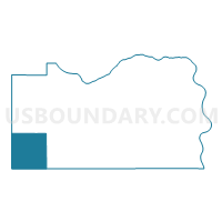
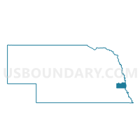
Tipton Precinct, Cass County, Nebraska
About
Outline

Summary
| Unique Area Identifier | 612537 |
| Name | Tipton Precinct |
| County | Cass County |
| State | Nebraska |
| Area (square miles) | 35.53 |
| Land Area (square miles) | 35.48 |
| Water Area (square miles) | 0.05 |
| % of Land Area | 99.86 |
| % of Water Area | 0.14 |
| Latitude of the Internal Point | 40.82297430 |
| Longtitude of the Internal Point | -96.39864070 |
Maps

Graphs
Select a template below for downloading or customizing gragh for Tipton Precinct, Cass County, Nebraska


Neighbors
Neighoring Voting District (by Name) Neighboring Voting District on the Map
- Elmwood Precinct, Cass County, NE
- Greenwood Precinct, Cass County, NE
- Palmyra Precinct, Otoe County, NE
- Russell Precinct, Otoe County, NE
- Stevens Creek Precinct, Lancaster County, NE
- Stockton Precinct, Lancaster County, NE
- Stove Creek Precinct, Cass County, NE
- Waverly 2 Precinct, Lancaster County, NE
Top 10 Neighboring County Subdivision (by Population) Neighboring County Subdivision on the Map
- Waverly precinct, Lancaster County, NE (3,605)
- Tipton precinct, Cass County, NE (2,160)
- North Palmyra precinct, Otoe County, NE (1,247)
- Stove Creek precinct, Cass County, NE (992)
- Stevens Creek precinct, Lancaster County, NE (964)
- Stockton precinct, Lancaster County, NE (888)
- Elmwood precinct, Cass County, NE (618)
- Greenwood precinct, Cass County, NE (470)
- North Russell precinct, Otoe County, NE (171)
Top 10 Neighboring Place (by Population) Neighboring Place on the Map
Top 10 Neighboring Unified School District (by Population) Neighboring Unified School District on the Map
Top 10 Neighboring State Legislative District Upper Chamber (by Population) Neighboring State Legislative District Upper Chamber on the Map
- State Senate District 25, NE (48,973)
- State Senate District 2, NE (35,052)
- State Senate District 1, NE (33,429)
Top 10 Neighboring 111th Congressional District (by Population) Neighboring 111th Congressional District on the Map
Top 10 Neighboring Census Tract (by Population) Neighboring Census Tract on the Map
- Census Tract 104, Lancaster County, NE (7,821)
- Census Tract 101, Lancaster County, NE (6,030)
- Census Tract 9659, Cass County, NE (4,998)
- Census Tract 9658, Cass County, NE (2,953)
- Census Tract 9668, Otoe County, NE (2,893)
Top 10 Neighboring 5-Digit ZIP Code Tabulation Area (by Population) Neighboring 5-Digit ZIP Code Tabulation Area on the Map
- 68462, NE (3,827)
- 68347, NE (2,570)
- 68520, NE (1,143)
- 68349, NE (1,098)
- 68418, NE (1,070)
- 68461, NE (734)
- 68527, NE (696)
- 68304, NE (330)